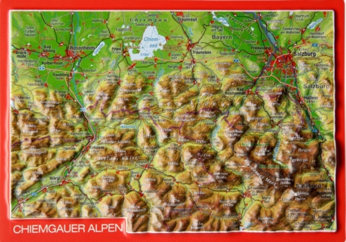
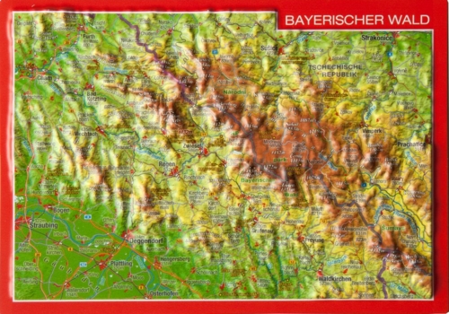
• georelief in Deutsch
  • Log in
  • Checkout
Call us: +49 (0) 351 / 79 27 5100 | E-mail: info@georelief.de
Georelief
  • HOME
  • Products
    • All products
    • NEWS
    • 3D Raised Relief Maps Europe
      • 3D Raised Relief Maps Germany
        • Baden-Wuerttemberg
        • Bavaria
        • Hamburg
        • Hessen
        • Mecklenburg-Vorpommern
        • Lower Saxony
        • North Rhine-Westphalia
        • Rhineland-Palatinate
        • Saxony
        • Saxony-Anhalt
        • Thuringia
      • France
      • Great Britain
      • Iceland
      • Italy
      • 3D Raised Relief Maps Austria
      • Poland
      • 3D Raised Relief Maps Switzerland
      • Scandinavia
      • Slowakia
      • Spain
      • Czech Republic
    • 3D Raised relief maps Africa
    • 3D Raised Relief Maps Asia
    • 3D Raised Relief Maps Mountains
    • 3D Raised Relief Maps Alps
    • Landscape
    • Accessories
      • Hook
      • Presentation
  • About us
  • Webcam
  • Contact us
  • Currency
    • EUR (Euro)
    • CHF (Swiss franc)
    • Information
  • Search
  • Menu
  • 0Shopping Cart
3D Raised Relief Map Bavarian Uplands small
You are here: Home / Shop / 3D Raised Relief Maps Europe / 3D Raised Relief Maps Germany / 3D Raised Relief Map Bavarian Uplands small

3D Raised Relief Map Bavarian Uplands small

19,95 € – 39,95 €

incl. VAT excl. Shipping

Our relief map Bavarian Oberland in the scale of 1:400,000 and a format (width/length/height) of 390 x 290 x 15 mm would like to recommend to you one of the most versatile and beautiful local recreation areas of Europe. From Munich to the Tyrolean Alps we have made this landscape decoratively and optically appealing.

Our relief postcard Bavarian Oberland is meant as a special greeting. Whoever sends this postcard can be sure to find it when visiting the addressee.

Clear
SKU: N/A Categories: 3D Raised Relief Maps Europe, 3D Raised Relief Maps Germany, All Products, Bavaria Tags: 3D, alps, bavaria, bavarian uplands, Munich, Raised relief map
  • Links in der Region
  • Description
Tourism Lake Starnberg
Tourism Garmisch-Partenkirchen
Tourism Bad Tölz
Tourism Tegernsee
Zugspitze

Description

Details 3D Raised Relief Map Bavarian Uplands (german): language german / scale 1:400.000

The large 3D Raised Relief Maps Bavarian Uplands from georelief are 100% made in Germany.

Because of that we can garantee high quality and topicality.

Tips and suggestions for your stay in the region can be found here.

The Bavarian Uplands is situated between Munich and the Alps. Because of that a lot of people visit this beautiful region every day.

Contact Germany

georelief Vertriebs GbR
Dohnaer Str. 383
D-01259 Dresden

Tel: +49 (0) 351 / 79 27 5100
Fax: +49 (0) 351 / 79 24 504
E-Mail: info@georelief.de

Our Partner in Schwitzerland

Georelief GmbH
Hauptstrasse 89
CH-8840 Einsiedeln

Tel: +41 (0) 554223315
Fax: +41 (0) 554223485
E-Mail: info@georelief.ch

Information

  • Imprint
  • Payment
  • Shipping
  • Terms and Conditions
  • Protection of data privacy
georelief © 2019. Alle Preise inkl. MwSt. zzgl. Versandkosten.
3D Raised Relief Map Allgaeu – Lake Constance large Dresden Postcard
Scroll to top

In order to give you a better service georelief uses cookies. By continuing to browse the site you are agreeing to our use of cookies.

OK
  • EUR
    Euro
  • CHF
    Schweizer Frank