• georelief in Deutsch
  • Log in
  • Checkout
Call us: +49 (0) 351 / 79 27 5100 | E-mail: info@georelief.de
Georelief
  • HOME
  • Products
    • All products
    • NEWS
    • 3D Raised Relief Maps Europe
      • 3D Raised Relief Maps Germany
        • Baden-Wuerttemberg
        • Bavaria
        • Hamburg
        • Hessen
        • Mecklenburg-Vorpommern
        • Lower Saxony
        • North Rhine-Westphalia
        • Rhineland-Palatinate
        • Saxony
        • Saxony-Anhalt
        • Thuringia
      • France
      • Great Britain
      • Iceland
      • Italy
      • 3D Raised Relief Maps Austria
      • Poland
      • 3D Raised Relief Maps Switzerland
      • Scandinavia
      • Slowakia
      • Spain
      • Czech Republic
    • 3D Raised relief maps Africa
    • 3D Raised Relief Maps Asia
    • 3D Raised Relief Maps Mountains
    • 3D Raised Relief Maps Alps
    • Landscape
    • Accessories
      • Hook
      • Presentation
  • About us
  • Webcam
  • Contact us
  • Currency
    • EUR (Euro)
    • CHF (Swiss franc)
    • Information
  • Search
  • Menu
  • 0Shopping Cart
West Ore Mountains
You are here: Home / Shop / 3D Raised Relief Maps Europe / 3D Raised Relief Maps Germany / West Ore Mountains
3D Reliefpostkarte Westerzgebirge

West Ore Mountains

3,95 €

incl. 19% VAT excl. Shipping

– Dimensions: 148 x 105 x 5mm

– Scale: 1: 500.000

– Boost factor: approx. 2.5

With our 3D relief postcard West Ore Mountains we delight above all the friends of winter sports and extensive hikes – for this region is very well known. On the postcard, you can see and feel the elevations and deep incisions of the area.

SKU: 4280000002723 Categories: 3D Raised Relief Maps Europe, 3D Raised Relief Maps Germany, All Products, Saxony Tags: 3D, Erzgebirge, Postkarte, Rahmen, Relief, rot, Sachsen, West
  • Links in der Region
  • Description
Tourism Oberwiesenthal
Fichtelberg
Keilberg / Klinovec
Tourism Karlsbad / Karlovy vary
Markus-Röhling-Stolln

Description

Tips and suggestions for your stay in the region can be found here:

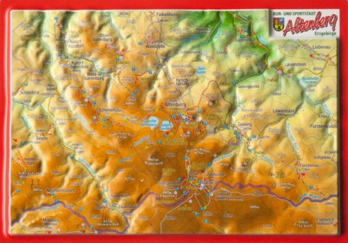
The Western side of the Ore Mountains borders on the Vogtland. It is geographically more strongly structured than the eastern part of the Ore Mountains.

It is characterized by high steps and deep forest valleys. The highest elevation of the Erzgebirge is the Fichtelberg with 1214 meters above sea level and the Auersberg which lies 1019 meters above sea level. On the Czech side, there is the Keilberg which lies 1244 meters above sea level.

Just like the entire Ore Mountain range, the West Ore Mountains benefited from rich silver finds at the end of the 15th century. Famous mountain towns such as Schneeberg and Annaberg emerged.

The Ore Mountain area is also known for its lace-making and the production of handmade wood products as well as the art of mining.

At the end of the 20th century, the mining industry was boosted again by uranium mining in the West of the Ore Mountains.

You may also like…

  • 1-Fach Display für Postkarten

    8,00 €

    incl. 19% VAT

    excl. Shipping

    Add to cart

Contact Germany

georelief Vertriebs GbR
Dohnaer Str. 383
D-01259 Dresden

Tel: +49 (0) 351 / 79 27 5100
Fax: +49 (0) 351 / 79 24 504
E-Mail: info@georelief.de

Our Partner in Schwitzerland

Georelief GmbH
Hauptstrasse 89
CH-8840 Einsiedeln

Tel: +41 (0) 554223315
Fax: +41 (0) 554223485
E-Mail: info@georelief.ch

Information

  • Imprint
  • Payment
  • Shipping
  • Terms and Conditions
  • Protection of data privacy
georelief © 2019. Alle Preise inkl. MwSt. zzgl. Versandkosten.
3D Raised Relief Map Harz small 3D Raised Relief Map Nepal Large
Scroll to top

In order to give you a better service georelief uses cookies. By continuing to browse the site you are agreeing to our use of cookies.

OK
  • EUR
    Euro
  • CHF
    Schweizer Frank