• georelief in Deutsch
  • Log in
  • Checkout
Call us: +49 (0) 351 / 79 27 5100 | E-mail: info@georelief.de
Georelief
  • HOME
  • Products
    • All products
    • NEWS
    • 3D Raised Relief Maps Europe
      • 3D Raised Relief Maps Germany
        • Baden-Wuerttemberg
        • Bavaria
        • Hamburg
        • Hessen
        • Mecklenburg-Vorpommern
        • Lower Saxony
        • North Rhine-Westphalia
        • Rhineland-Palatinate
        • Saxony
        • Saxony-Anhalt
        • Thuringia
      • France
      • Great Britain
      • Iceland
      • Italy
      • 3D Raised Relief Maps Austria
      • Poland
      • 3D Raised Relief Maps Switzerland
      • Scandinavia
      • Slowakia
      • Spain
      • Czech Republic
    • 3D Raised relief maps Africa
    • 3D Raised Relief Maps Asia
    • 3D Raised Relief Maps Mountains
    • 3D Raised Relief Maps Alps
    • Landscape
    • Accessories
      • Hook
      • Presentation
  • About us
  • Webcam
  • Contact us
  • Currency
    • EUR (Euro)
    • CHF (Swiss franc)
    • Information
  • Search
  • Menu
  • 0Shopping Cart
East Ore Mountains
You are here: Home / Shop / 3D Raised Relief Maps Europe / 3D Raised Relief Maps Germany / East Ore Mountains

East Ore Mountains

3,95 €

incl. 19% VAT excl. Shipping

Our relief postcard East Ore Mountains impressively illustrates the eastern part of the highest Saxon mountains. Send the peaks, some of which are more than 900m high, comfortably by post.

– Dimensions: 148 x 105 x 5mm

– scale: 1: 500.000

– Boost factor: approx. 3

SKU: 4280000002686 Categories: 3D Raised Relief Maps Europe, 3D Raised Relief Maps Germany, All Products, Saxony Tags: Bergbau, Erzgebirge, Holzschnitzregion, Postkarte, Relief, Sachsen
  • Links in der Region
  • Description
Tourism East Ore Mountains
Tourism Altenberg
Tourism Seiffen
Racing sled and bobsleigh track
Weißeritztal Railway
Visitor Mine Zinnwald

Description

Tips and suggestions for your stay in the region can be found here

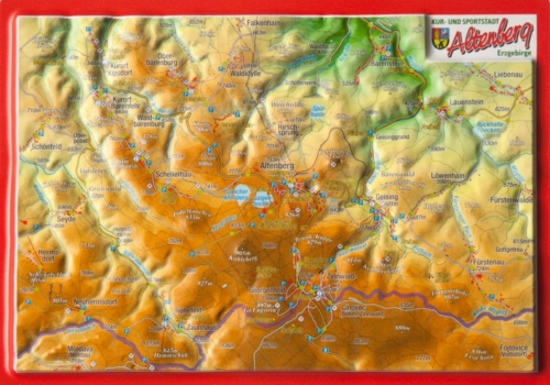
When the weather is fine, the ridge of the East Ore mountain towers high above the Elbe Valley and the Bohemian Basin in the Czech Republic, visible even from the Saxon state capital, Dresden.

Sports recreation and tradition are at the top of the list of recreation seekers. International competitions regularly take place on the bobsleigh track in Altenberg or the biathlon arena in Zinnwald. As soon as the weather permits, the well-developed network of cross-country ski trails in the snow-covered winter forests is prepared. If the weather is too rough on the peaks, Germany’s oldest narrow-gauge railway, the Weißeritztal Railway invites you to take a romantic ride through the idyllic valley of the same name. In one of the mines, tourists can learn that the Erzgebirge was not given its name by chance. Every year in December, and sometimes even a little earlier, the entire Erzgebirge transforms into a single Christmas fairytale land. The tradition of wood carving is still alive today, for example in the toy country in Seiffen.

Since this dreamlike region has much more to offer, you have to find out for yourself. But our relief postcard will help you plan your trip.

You may also like…

  • 1-Fach Display für Postkarten

    8,00 €

    incl. 19% VAT

    excl. Shipping

    Add to cart

Contact Germany

georelief Vertriebs GbR
Dohnaer Str. 383
D-01259 Dresden

Tel: +49 (0) 351 / 79 27 5100
Fax: +49 (0) 351 / 79 24 504
E-Mail: info@georelief.de

Our Partner in Schwitzerland

Georelief GmbH
Hauptstrasse 89
CH-8840 Einsiedeln

Tel: +41 (0) 554223315
Fax: +41 (0) 554223485
E-Mail: info@georelief.ch

Information

  • Imprint
  • Payment
  • Shipping
  • Terms and Conditions
  • Protection of data privacy
georelief © 2019. Alle Preise inkl. MwSt. zzgl. Versandkosten.
3D Raised Relief Map Harz small 3D Raised Relief Map Nepal Large
Scroll to top

In order to give you a better service georelief uses cookies. By continuing to browse the site you are agreeing to our use of cookies.

OK
  • EUR
    Euro
  • CHF
    Schweizer Frank